
Please use your device in landscape view.
Geyser Park and the Trolley
Hudson Valley Railway
As a child I often visited Geyser Park1, picnicking with my family along the picturesque Geyser Creek. Although I was vaguely aware of the long abandoned D&H railroad embankment, ironically—until recently—I had absolutely no idea that a trolley at one time ran through the park!
As mentioned, according to Interurbans of the Empire State2, the 2.3 mile route to the Geysers was built in in 1890. It took passengers from downtown Saratoga first to the Lincoln and Washington Baths, then to Geyser Park. As the line expanded, travel continued on south to Ballston Spa and on to Schenectady.
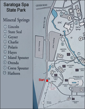
According to the Friends of Saratoga Spa State Park, the still functioning dam on Geyser Brook is where the trolley crossed the creek and on the slope above, the broad trail roughly follows the original track southward to Coesa Spring, one of the street car's numerous stops.
The OpenStreetMap approximately indicates portions of the route, but much has been obliterated due to the various new facilities constructed on the right of way.

On Friday, February 28th, 2014, accompanied by my good friend from high school, Gary Cunningham, we braved the bitter temperatures (around 10°- yikes!) and retraced the ROW within the Park as best we could. Although much of the ROW has been obliterated by the clearings created for the various picnic areas, with the help of the OpenStreetMap and Acme Mapper aerials, we managed. Our findings are presented below, going in a south to north direction.
Be sure to read the article on The History of the Geyser Park Mineral Springs. It's a quick read and a fascinating summation of this locale’s history.
Comparison Map

Retracing the Geyser Park Trolley ROW
We started our trek at the the Hathorn Spring entrance. The Park roadway was closed but the road was plowed so we walked down to the Carlsbad Parking lot intersection. According to the OpenStreet Map, the Trolley line followed the Carlsbad Road north to the East West Road intersection then shot straight north to the west of the loop.


We trekked northward thru the woods and field directly to the west of the loop but didn’t really see anything that indicated the trolley ROW until we got near the back of the building complex and “picked up the scent” so to speak when the the path through the trees became more apparent.


Next we hiked thru the woods on the old right a way and crossed over an unplowed Picnic Lane where the ROW became more obscure. Fortunately, right after crossing through the next picnic area, the scent was strong again! Our trek took us right across thru the woods, and on an old large trolley embankment over a stream gully. It then brought us out to the next picnic area - Orenda Spring.


We doned our snowshoes and trekked across the field, finally sidetracking down a small gully to get to the creek. At that point we walked north on the park trail to Orenda spring where the ROW became apparent on the west side of the river only. It veered off on a nice curve westward and lined up nicely with the dam. At this point, the ROW traveled over the creek at the dam so there must have been some kind of trestle here...


Across the River, the entire area has been re-landscaped for SPAC and other out buildings so there wasn’t any perceptible signs of the ROW to be found.
Thoughts...
Once again—like Alplaus and Rexford—the history of the trolley has been strangely omitted. Its a disturbing re-occurrence that preservationists and historical societies repeatedly ignore the trolley as part of history worth noting. Dare I say—like some eccentric great grandfather your proud family pretends didn't exist—mention of trolleys in historical plaques and signage more often than not has been completely eradicated...
I think the vibrant and fascinating history of Saratoga would be enhanced by noting the trolley's existence and better yet... marking at least some of the ROW remnants we traversed as "built by the trolley companies". Future trails in the south of the park, all the way to Ballston Spa, are in the works based on the routes of the trolley. Perhaps when these are complete, proper signage will pay tribute to the trolleys of yesteryear, Until then, try to explore the park with this site as a knowledge guide for the trolley history you can find.
_______________
- Now known as the Saratoga Spa State Park
- Interurbans of the Empire State (a book by Felix E. Reifschneider)